Under the princely rulers of Chamba, any state official posted to Pangi was paid a special allowance before he left. It was booked under the heading funeral expenses – because his return, alive or at all, was not considered a reasonable expectation.
That line survives in the district records, and it is still the most honest introduction to the place. Pangi Valley, in Chamba district of Himachal Pradesh, is a remote tehsil wedged between the Zanskar range to the north and the Pir Panjal to the south, with the Chandrabhaga – the Chenab – cutting through it in a gorge on its way into the Paddar region of Jammu and Kashmir. Around 18,868 people live there. A road connecting it to the rest of the state arrived only in the mid-1990s.
This is not a trip report. It is an attempt to explain what Pangi Valley actually is – who lives there, why it was sealed off for so long, and what is changing now – with the things that go out of date clearly marked as such.
Contents
- Pangi Valley in numbers
- Pangi Chamba: where Pangi Valley actually is
- Churah Chamba and the route to Pangi
- Pangi altitude: how high is Pangi Valley?
- Chamba to Pangi: three routes into the valley
- Why Pangi Valley is cut off in winter
- Pangwals and Bhots
- Jukaru, Dashalu and Mindhal Mata
- How people make a living
- Visiting Pangi Valley: what you need to know
- Pangi Valley at a glance
- Frequently asked questions
Pangi Valley in numbers
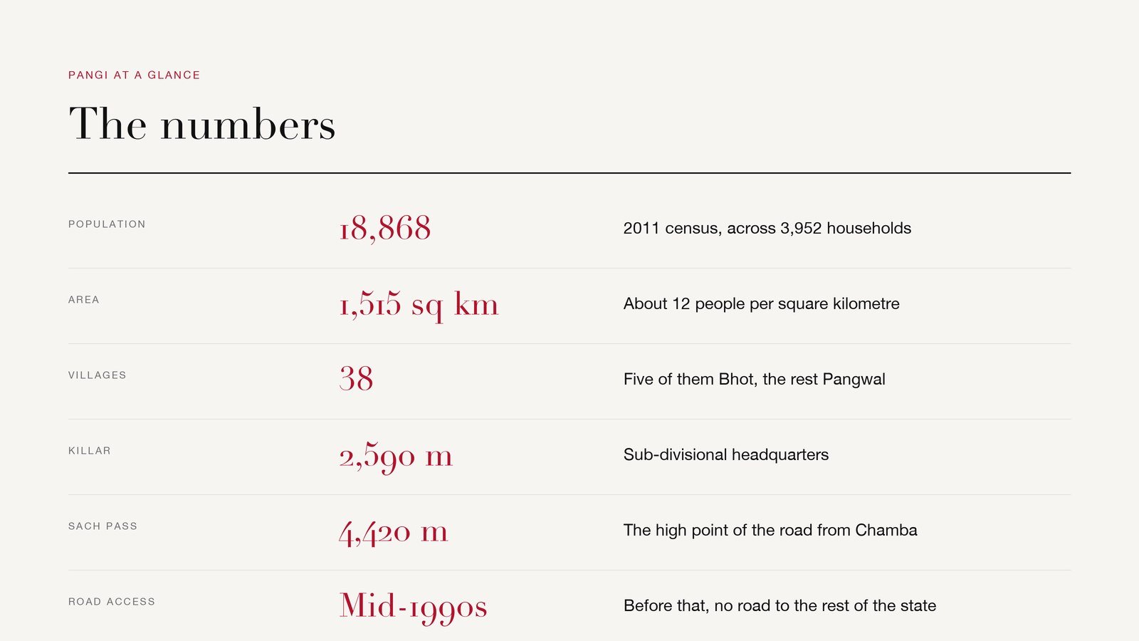
Pangi Valley altitude varies considerably across the region, with inhabited areas generally between 2,100 and 3,400 metres above sea level. Killar, the headquarters of Pangi, sits at around 2,590 metres.
| Measure | Figure | Note |
|---|---|---|
| Population | 18,868 | 2011 census; 9,579 male, 9,289 female |
| Households | 3,952 | Across the whole tehsil |
| Area | 1,515 sq km | Roughly 12 people per sq km |
| Villages | 38 | Five are Bhot settlements |
| Inhabited range | 2,100–3,400 m | About 7,000 to 11,000 ft |
| Killar | 2,590 m | Sub-divisional headquarters |
| Sach Pass | 4,420 m | High point of the Chamba road |
Pangi Chamba: where Pangi Valley actually is
Pangi Valley is a remote tehsil of Chamba district in Himachal Pradesh. It lies in the northern part of the district, between the Zanskar and Pir Panjal ranges, centred on the Chandrabhaga (Chenab). Killar is its administrative headquarters.
Look at a map of Himachal Pradesh and find the top-left corner. Pangi is the piece that looks like it should belong to somewhere else – it borders Lahaul and Spiti on its eastern side and Jammu and Kashmir to the north and north-west, and it is separated from the rest of Chamba district by a wall of mountains that is passable for a few months a year.
The valley is organised around water rather than roads. The Chandrabhaga runs through the middle of it in a deep, narrow gorge, and the settlements sit on the terraces and side valleys above it. Three of those side valleys – Saichu, Hudan Bhatori and Sural Bhatori – are effectively valleys within the valley, each with its own character.
The result is a place where “remote” is not a marketing word. Pangi Valley is not remote from a city; it is remote from the district it belongs to.
Churah Chamba and the route to Pangi
Between Chamba town and Pangi sits Churah, a sub-division of Chamba district with its headquarters at Tissa. Every road account of Pangi passes through it: the route from Chamba runs up through Churah to Tissa, then on to Bairagarh, over Sach Pass and down to Killar. The chain worth holding in your head is Chamba → Churah → Tissa → Bairagarh → Sach Pass → Killar → Pangi.
Pangi altitude: how high is Pangi Valley?
The altitude of Pangi Valley varies from village to village and across the mountains around them. Most inhabited parts of the valley are roughly 2,100-3,400 metres (7,000-11,000 ft) above sea level. Killar, the administrative headquarters, stands at about 2,590 metres (8,500 ft), while the road in from Chamba climbs far higher, to Sach Pass at around 4,420 metres (14,500 ft).
That spread is why the valley feels like two places. The lower Pangwal villages along the Chandrabhaga grow fruit; the Bhot settlements above them are high enough for yak.
Chamba to Pangi: three routes into the valley
Chamba to Pangi via Sach Pass
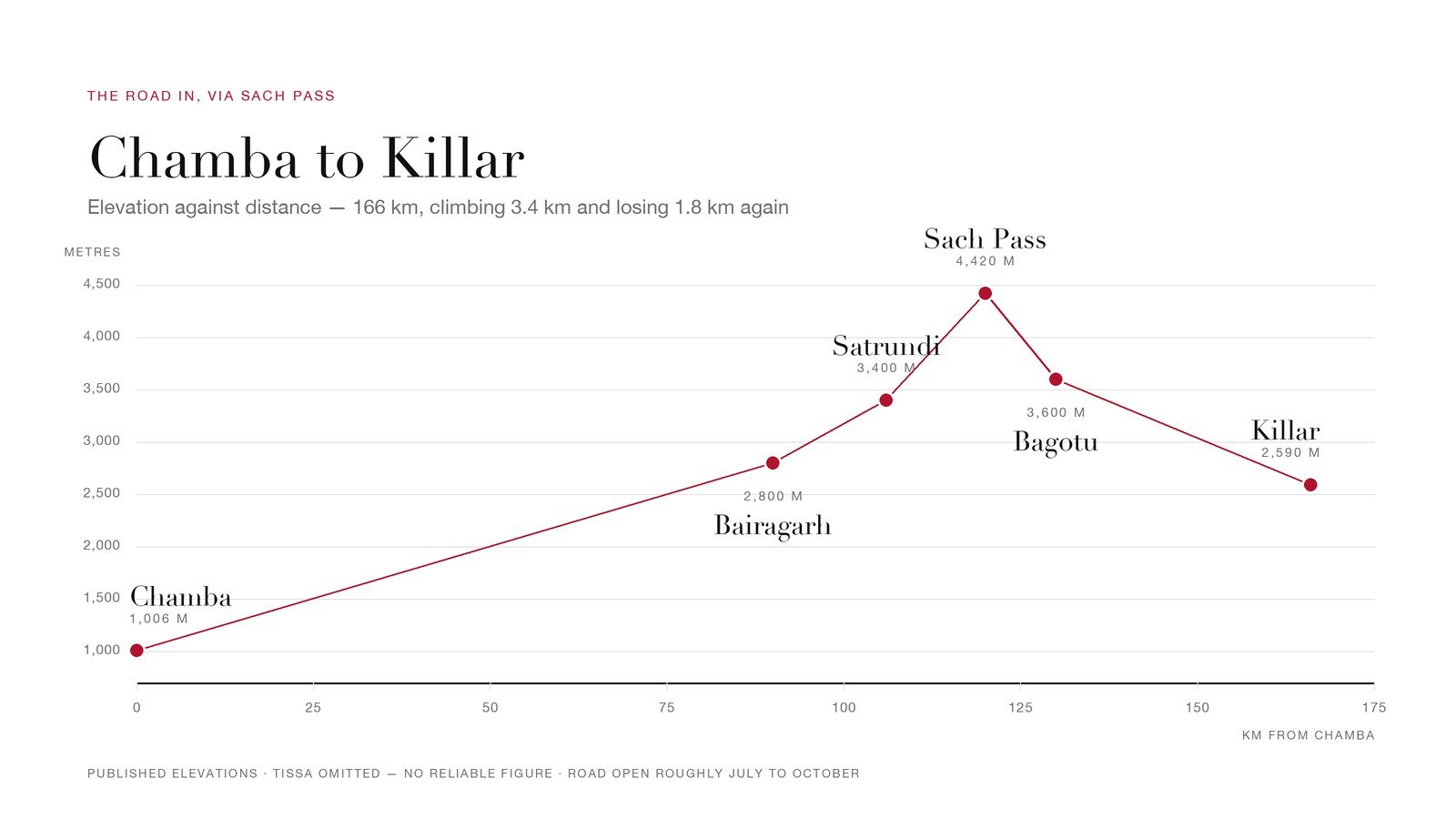
The Chamba to Pangi route over Sach Pass is the shortest road approach, and also the highest and the most weather-dependent. Sach Pass tops out at 4,420 m on the Pir Panjal, and the road runs Chamba – Tissa – Bairagarh – Satrundi – the pass – Bagotu – Killar.
| Point on the route | Distance from Chamba |
|---|---|
| Tissa | 63 km |
| Bairagarh | 90 km |
| Satrundi | 106 km |
| Sach Pass | 120 km |
| Bagotu | 130 km |
| Killar | 166 km |
Read down the column, not across: these are cumulative distances measured from Chamba, so Chamba to Killar in Pangi Valley is roughly 166 km via Sach Pass. Driving time is a different question entirely, and depends on the state of the road on the day.
The road opens once the Border Roads Organisation has finished clearing it, usually somewhere between late June and early July, and closes again when heavy snow returns, typically from October. HRTC runs a bus over it during that window. Opening and closing dates move by weeks from one year to the next, so confirm the current status before setting out.
Along the Chenab, from Lahaul
The gentler option. From Manali over Rohtang or through the Atal Tunnel into Lahaul, then down the Chenab through Udaipur and Tindi to Killar. Longer, lower, and considerably less alarming.
From Kishtwar, in Jammu and Kashmir
The Killar–Kishtwar road is the one that turns up in “world’s most dangerous roads” lists, and for once the description is not entirely invented: a single-lane shelf cut into cliff face, no barrier, and a long drop to the Chenab. It is a working road that local people use, not a stunt — but it is not a road to take casually or in bad weather.
| Route | Via | Character | Usual window |
|---|---|---|---|
| From Chamba | Sach Pass, 4,420 m | Shortest, roughest, highest | Late June/July to October |
| From Manali | Lahaul, Udaipur, Tindi | Longest, lowest, safest | Longer season, snow-dependent |
| From Kishtwar | Chenab gorge | Cliff shelf, single lane | Conditions-dependent |
Road status in Pangi Valley changes year to year and week to week. Treat every date above as a pattern, not a promise, and confirm with HPPWD, the BRO or the district administration before you travel.
Why Pangi Valley is cut off in winter
Roughly from November to May, the passes close and Pangi Valley is on its own. Sach Pass is under snow. The Lahaul road becomes unreliable. There is no road in and no road out.
What that means in practice is that everything a household will need for the winter has to be inside the house before the snow: grain, fuel, fodder, medicine. Helicopter services operate — but as a lifeline for emergencies and supplies, subject to weather, not as a timetable anybody can plan around.
This is the fact underneath everything else about the valley. The architecture, the storage, the calendar of festivals, the fact that the biggest celebration of the year falls in the middle of February — all of it is shaped by a winter that cannot be left.
Pangwals and Bhots
Two communities share Pangi Valley, and the distinction is geographic as much as cultural.
The Pangwals are the majority, living in the lower and middle villages along the Chandrabhaga and its tributaries. They are Hindu, and they speak Pangwali, a Western Pahari language.
The Bhots are of Indo-Tibetan descent, Buddhist, and live higher up in five villages: Hudan Bhatori, Sural Bhatori, Parmar Bhatori, Chasak Bhatori and Hill Twan. Bhatori is simply the local word for these high settlements. They speak Bhoti among themselves and Pangwali when dealing with their Pangwal neighbours — a small detail that says a lot about how the two communities actually get along.
Sural Bhatori and Hudan Bhatori each have a gompa, the one at Sural set in a stand of bhojpatra, the Himalayan birch whose bark was used for manuscripts. You can walk from a Hindu village to a Buddhist one in a morning, which makes Pangi Valley one of the more quietly interesting religious landscapes in the western Himalaya.
Jukaru, Dashalu and Mindhal Mata
Jukaru is the big one — a twelve-day festival in mid-February, at the deepest point of the winter, when nobody is going anywhere anyway. It is a thanksgiving for having survived the worst of the year so far and a deliberate act of social repair: visiting, feasting, settling things.
The tenth day is Dashalu, when a fair is held and special worship is performed at the Mindhal Mata temple — people crossing snow to get there. The temple stands on the left bank of the Chenab and is dedicated to Durga, identified locally with Chamunda. It is the most important shrine in the valley and draws pilgrims from the neighbouring valleys too.
The Pangwal year also takes in Sair, tied to the agricultural cycle, alongside Dussehra, Diwali and Shivratri.
How people make a living
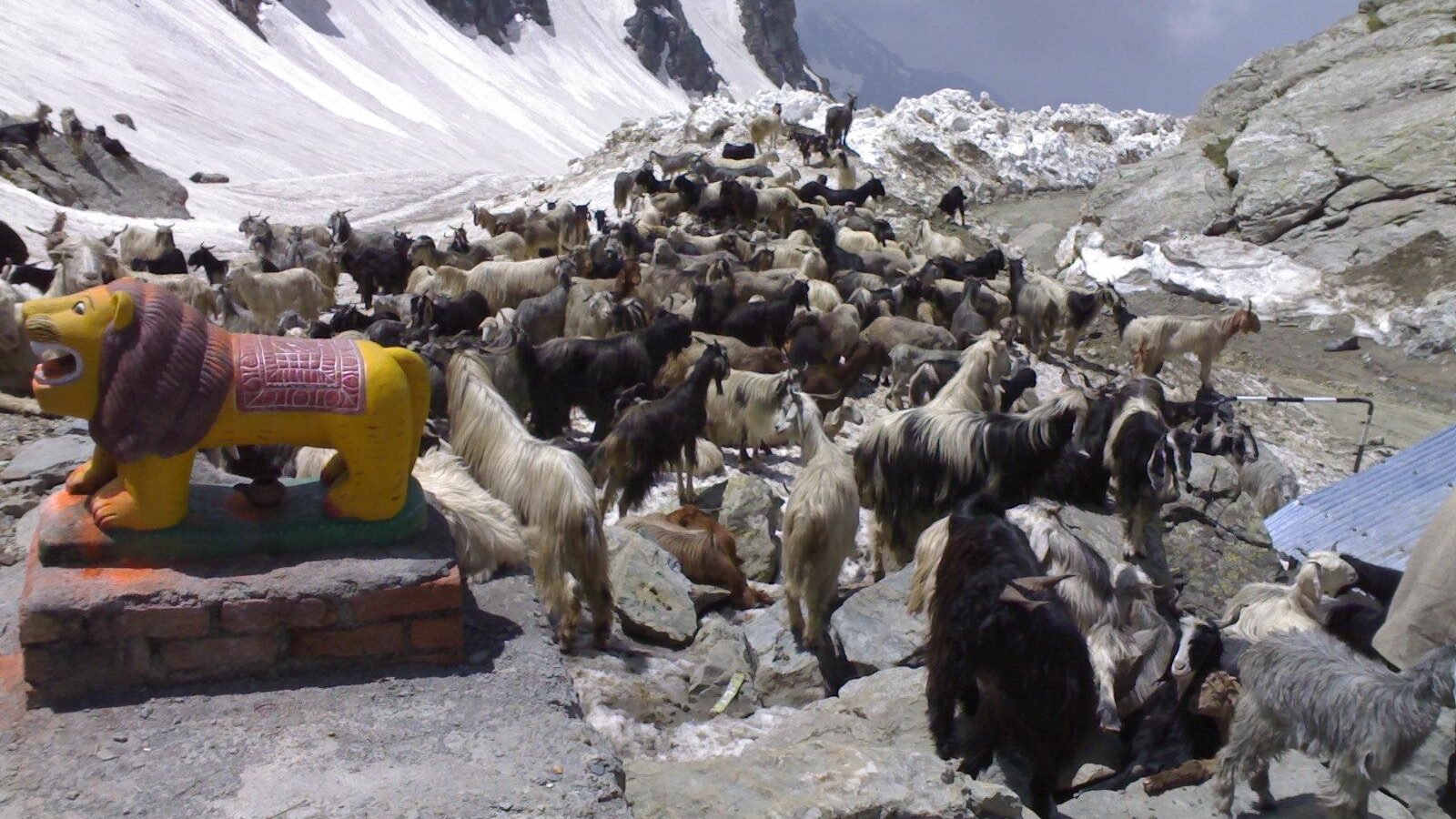
Terrace farming, mostly, on whatever ground will hold soil. Barley and buckwheat are the traditional crops; potato, peas, rajma and cauliflower have come in more recently, and there is plum, apple and apricot. Pangwal households keep sheep and goats. Bhot households, higher up, keep yak and weave wool.
The interesting development is what the state is now doing with Pangi’s traditional agriculture. In June 2025 the Himachal Pradesh government announced that Pangi Valley would become the state’s first natural farming sub-division, with certification under the Participatory Guarantee Scheme through the Prakritik Kheti Khushhal Kisan Yojana.
The logic is neat: isolation that was purely a liability becomes an asset. A valley that never industrialised its agriculture, because it could not get the inputs in, is already most of the way to certified natural farming. Whether that translates into prices worth the effort depends on getting the produce out — which brings the story back to the roads.
Visiting Pangi Valley: what you need to know
The season is short — broadly late June to early October, dictated by the passes. Killar is the base. Homestays exist and are the sensible choice, both because hotel infrastructure is thin and because the money stays in the valley.
Three things worth being honest about. Mobile coverage and banking are limited, so carry cash and do not assume connectivity. Medical facilities are basic and the nearest real hospital is a long way over a mountain. And Pangi Valley is a Scheduled Tribe area where people live with genuine constraints — it is somebody’s home before it is anybody’s road trip.
Everything in this section is the kind of detail that changes. Check current conditions with the Himachal Pradesh tourism department and the district administration before committing to anything.
Pangi Valley at a glance
| Information | Answer |
|---|---|
| Location | Chamba district, Himachal Pradesh |
| Headquarters | Killar |
| Pangi altitude | About 2,100–3,400 m in inhabited areas |
| Killar altitude | About 2,590 m |
| Sach Pass altitude | About 4,420 m |
| Chamba to Killar | About 166 km via Sach Pass |
| Main language | Pangwali |
| Major winter festival | Jukaru, mid-February |
Frequently asked questions
Where is Pangi Valley in Chamba?
Pangi Valley is in the far north of Chamba district, Himachal Pradesh. It lies between the Zanskar and Pir Panjal ranges, along the Chandrabhaga (Chenab), and borders Lahaul and Spiti to the east and Jammu and Kashmir to the north and north-west.
What is the altitude of Pangi Valley?
The inhabited parts of Pangi Valley are generally between 2,100 and 3,400 metres above sea level, or roughly 7,000 to 11,000 ft. Killar, the headquarters of Pangi, is at about 2,590 m.
How far is Chamba to Pangi?
The road from Chamba to Killar in Pangi Valley is about 166 km via Sach Pass. How long that takes, and whether it is possible at all, depends on the condition of the road and the status of the pass.
How do you reach Pangi Valley from Chamba?
The main Chamba to Pangi route goes through Tissa, Bairagarh and Satrundi, over Sach Pass, and down to Killar. The two alternatives come from outside the district: down the Chenab from Lahaul via Udaipur and Tindi, or from Kishtwar in Jammu and Kashmir along the cliff road. All three are seasonal and all three should be checked before travelling.
What is Churah Chamba?
Churah is a region and sub-division of Chamba district in Himachal Pradesh, with Tissa as its headquarters. It is the stretch of the Chamba side of the journey that the road to Sach Pass and Pangi Valley passes through.
What is the altitude of Sach Pass?
4,420 m, or about 14,500 ft, on the Pir Panjal range. It is 120 km from Chamba on the road to Killar.
Is Pangi Valley cut off in winter?
Yes. From roughly November to May there is no reliable road access in or out. Helicopter services run for emergencies and supplies, weather permitting, but not to a schedule.
What is the best time to visit Pangi Valley?
Broadly late June to early October, which is when the passes are open. Outside that window the valley is effectively closed to road traffic.
Who lives in Pangi Valley?
Around 18,868 people at the 2011 census. The majority are Pangwals, who are Hindu and speak Pangwali. A Bhot minority of Indo-Tibetan descent, who are Buddhist and speak Bhoti, live in five high villages known as bhatoris.
What language is spoken in Pangi Valley?
Pangwali, a Western Pahari language, is the main one. Bhoti is spoken in the Bhot villages, whose residents generally speak Pangwali as well.
The short version
Pangi Valley is a place that spent most of its history being difficult to reach and has spent the last thirty years slowly becoming reachable. It has a road now, for part of the year. It has mobile signal, in places. It is about to become the first natural farming sub-division in Himachal Pradesh — an idea that only makes sense somewhere that was never able to farm any other way.
What has not changed is the winter, and the fact that 18,868 people organise their year around it. The funeral-expenses allowance is gone. The mountain it was paid for is not.
More from Cloud Bawa: further reporting from the Culture desk, or start again from the Cloudbawa homepage.